


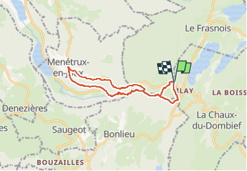
Ilay Menetrux en Joux cascades du Herisson page 98

grasgilbert
User

Length
12.7 km

Max alt
775 m

Uphill gradient
384 m
Km-Effort
17.8 km

Min alt
525 m

Downhill gradient
383 m
Boucle
Yes
Creation date :
2024-04-07 12:12:34.486
Updated on :
2024-05-14 14:45:52.485
4h02
Difficulty : Difficult

FREE GPS app for hiking
 SityTrail
IGN / Geographical institutes
SityTrail Plus
The world is yours!
About
Trail Walking of 12.7 km to be discovered at Bourgogne-Franche-Comté, Jura, Le Frasnois. This trail is proposed by grasgilbert.
Description
très difficile pour randonneurs avertis bien chaussé
Photos


Positioning
Country:
France
Region :
Bourgogne-Franche-Comté
Department/Province :
Jura
Municipality :
Le Frasnois
Location:
Unknown
Start:(Dec)
Start:(UTM)
720661 ; 5166762 (31T) N.
Comments